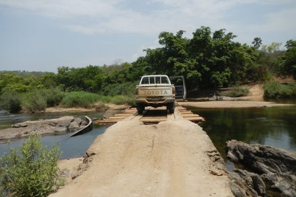
The Federal Government should urgently take steps to develop the Gashaka-Gumti National Park (GGNP) in Taraba State into a tourism site to avoid the reserve being turned into a hideout for terrorists, the state governor, Darius Ishaku, has warned.
Safari at the Gashaka-Gumti National Park. There are fears that its continous neglect could make it another Sambisa Forest, and an haven for insurgents
The governor said the GGNP, gazetted from two game reserves in 1991, should never be allowed to go the way of Sambisa Forest, where Boko Haram terrorists are believed to be holding out. The GGNP is Nigeria’s largest national park and one of the largest parks in West Africa.
The park, which is managed by the Nigerian Tourism Development Corporation (NTDC), covers a large expanse of land traversing Taraba and Adamawa states. Gashaka-Gumti National Park was created by a Federal Decree in 1991 by the merging of Gashaka Game Reserve with Gumti Game Reserve.
Ishaku, in a statement issued on his behalf by Mr Emmanuel Bello, Senior Special Assistant to the Governor on Public Affairs, in Jalingo, the state capital, said the Nigerian government must ask itself some pertinent questions which has to do with Sambisa following its capture.
“After the capture of Sambisa Forest, one of the things the Federal Government must ask itself is how that forest became a breeding ground for the type of atrocity that reportedly went on there. Ordinarily, Sambisa should have been a paradise on earth with its potential for tourism and scientific researches. Today, the name, Sambisa, may forever be associated with negativity. I call on the Federal Government to be proactive about tourism,” the governor was quoted as saying in the statement
The governor also called on the Federal Government, following the capture of Sambisa by Nigerian troops, to concentrate its efforts on developing tourism potential of other forest reserves so that they are not allowed to become another hideout for criminals.
The statement reads, “We may never know, but if that Sambisa forest was put to good use, who knows, maybe we would have been spared all the horrors. Please, let this not become the fate of another potential paradise called Gashaka-Gumti.”
The governor noted that, on its part, it was doing its best to develop the park and called on the Federal Government to shift its focus to harnessing the tourism potential of the park and those of others and thus develop tourism.
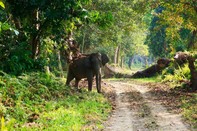
Gashaka-Gumti National Park is located in a mountainous region of North-east Nigeria adjacent to the international border with Cameroon, and immediately to the North of the Mambilla plateau. No roads cross this remote region and only a few lonely footpaths wind through the forested mountains towards Cameroon. Visitors to the park are able to enjoy lush forests, wide sweeping grasslands, cool highland plateaus, rugged moody mountains, abundant wildlife, and fascinating ethnic cultures, all combined within a single protected area.
Gashaka-Gumti National Park
There are few other places in the world that contain such spectacular scenery and such diverse wildlife. The hidden corner of West Africa that is Gashaka-Gumti National Park is surely one of the continent’s best kept secrets.
Gashaka-Gumti National Park, the largest park in Nigeria, covers 6,731 sq km of wilderness. The park’s name is derived from two of the region’s oldest and most historic settlements: Gashaka village in Taraba State, and Gumti village in Adamawa State. Gashaka-Gumti National Park was created by Federal Decree in 1991 by the merging of Gashaka Game Reserve with Gumti Game Reserve. In this guidebook we will use the term Gashaka sector to indicate the Southern half of the park, and the term Gumti sector to indicate the Northern half.
The Northern, Gumti sector of the park is relatively flat and covered with woodlands and grasslands, whilst the Southern, Gashaka sector is more mountainous and contains vast expanses of rainforest as well as areas of woodlands and montane grassland. This rugged terrain is characterised by steep, thickly forested slopes, deep plunging valleys, precipitous escarpments and swiftly flowing rivers. Altitude ranges from 450 metres above sea level in the wild savannah plains of the Northern sector, to the peaks and pinnacles of Gangirwal in the Southern park sector, which at a staggering 2,400 metres above sea level, represents Nigeria’s highest mountain.
It is the sheer variety of different habitats within Gashaka-Gumti National Park that makes the area so uniquely rich in wildlife. In fact the park is actually an intricate mosaic of montane grasslands, savannah woodlands, swamps, lakes, mighty rivers, dark lowland rainforests, and luxuriant, montane rainforests strewn with ferns and orchids. Each habitat supports its own distinctive community of plants and animals.
Rainforests provide a haven for animals such as the Giant forest hog, leopard, Yellow-backed duiker, Golden cat, and many different primate species including chimpanzees. Woodland savannahs are home to buffalo, lion, elephant, and Wild dog, as well as various antelopes such as waterbuck, Roan antelope, kob, hartebeest and the world’s largest antelope, the Giant eland. The mountains of the park harbour populations of the rare Adamawa mountain reedbuck, in addition to Black-and-white colobus monkey, baboon, warthog, oribi, and klipspringer. Whilst its largest unspoilt rivers contain hippos, crocodiles, otters and a wide variety of fishes. The park is officially labelled as one of Africa’s “Important Bird Areas” – and with more than 500 species found here, this is certainly no exaggeration. Visiting bird watchers constantly add new species to the list. An additional abundance of creatures such as butterflies, flowers and trees, makes this park a naturalists’ paradise, unrivalled anywhere for diversity.
If current trends continue and the world fails to reduce greenhouse gas emissions, nearly all of the world’s coral reefs will suffer severe bleaching – the gravest threat to one of the Earth’s most important ecosystems – on annual basis, the United Nations Environment Programme (UNEP) has said Climate Change.
Bleached coral reefs
The finding is part of a study funded by UNEP and partners, which reviewed new climate change projections to predict which corals will be affected first and at what rate. The report is published in the journal Nature Scientific Reports.
When water is too warm, corals will expel the algae (zooxanthellae) living in their tissues causing the coral to bleach, or turn completely white. This is called coral bleaching.
Researchers found that the reefs in Taiwan and the Turks and Caicos archipelago will be among the first to experience annual bleaching, followed by reefs off the coast of Bahrain, in Chile and in French Polynesia.
Calling the predictions “a treasure trove” for environmentalists, the head of UNEP, Erik Solheim, said the projects allow conservationists and governments to prioritise the protection reef protection.
“The projections show us where we still have time to act before it’s too late,” Mr. Solheim said.
On average, the reefs will start to undergo annual bleaching starting in 2014, according to the study. Without the required minimum of five years to regenerate, the annual occurrences will have a deadly effect on the corals and disrupt the ecosystems which they support.
However, if Governments act on emission reduction pledges made in the Paris Agreement, which calls on countries to combat climate change and limit global temperature rise to below 2 degrees Celsius, the corals would have another 11 years to adapt to the warming seas.
Between 2014 and 2016, the world witnessed the longest global bleaching event recorded. Among the casualties was the Great Barrier Reef, with 90 per cent of it bleached and 20 per cent of the reef’s coral killed.
Ebola has proven itself a tricky foe to get rid of in the human body. In numerous cases in which it was thought to be gone and patients fully recovered, the virus has been found in the eyes, semen, amniotic fluid, placenta, breast milk and central nervous system.
A victim of Ebola virus
Now a paper published in the journal PLOS Pathogens describes another possible hiding place for the virus: the lungs.
The case study involves a health-care worker who was infected in Sierra Leone and moved to a hospital in Rome for treatment. Doctors were surprised that after the virus had been cleared from the patient’s blood plasma, it could still be found in the lower respiratory tract.
Study author Giuseppe Ippolito of Italy’s National Institute for Infectious Disease said that previous studies in the lab, in animals and in patients have suggested that Ebola might cause lung damage because of replicating virus in the lungs, but that there had been no direct evidence of lung infection until now.
The paper notes that researchers found viral RNA and viral replication markers in the lungs for five days after Ebola was cleared from the blood and that the patient “developed significant lung injury.”
“This suggests a major role of the respiratory tissues in the pathogenesis of Ebola virus disease,” Ippolito and his colleagues wrote.
These findings are significant because, if confirmed, they suggest that new ways of monitoring survivors may be needed as well as possible new treatments.
The cup of joe that helped you get through the morning, the must-have chair purchased at that trendy furniture store and the palm oil that’s key to a favorite family recipe all have elements ripped from the habitat of a threatened or endangered animal somewhere in the world.
A hydroelectric dam that traps water to irrigate agriculture, including trees that produce palm oil exported to other parts of Europe and the United States, threatens the Iberian lynx
Goods that sit in stores across the United States had their origins in areas where monkeys, toads, sea cows and big cats live. Those elements, which animals in shrinking habitats need to survive, are used in products made by 15,000 industries worldwide and consumed in 187 countries, disproportionately in the United States and Europe. More than 6,500 species of wildlife suffer because of it.
This was first quantified in 2012, when scientists estimated that trade and exports accounted for a third of all threats to wildlife. But for the first time, a study by researchers in Japan and Norway pinpoints the affected habitats of all those species – in the hope of helping to focus the work of conservationists who track the effect of human trade.
The researchers, Daniel Moran of the Norwegian University of Science and Technology and Keiichiro Kanemoto of Shinshu University in Japan, laid relatively new global supply-chain databases over the habitats of endangered species listed by the International Union for the Conservation of Nature (IUCN) and BirdLife International. That identified areas the scientists call threatened biodiversity hotspots. The research was published this week in the journal Nature Ecology and Evolution.
A biodiversity hotspot is a biogeographic region that is both a significant reservoir of biodiversity and is threatened with destruction. The term biodiversity hotspot specifically refers to 25 biologically rich areas around the world that have lost at least 70 percent of their original habitat.
“Biodiversity hotspot is a well studied topic, and it is known that the last reserves of biodiversity are harbored in a small number of places,” Moran said on Wednesday by email. “Economic pressure, even at the margin and in small increments, exerts pressure at these places. Almost any human pressure at the places, unless very well managed, will have a big impact on species there.”
Logging in Brazil to create products that wind up in the United States, for example, cuts down trees used by red-face spider monkeys. Fishery trade and gold mined and bound for Japan affects mangroves off Papua New Guinea that are home to diverse plant species and an endangered sea cow. A hydroelectric dam that traps water to irrigate agriculture, including trees that produce palm oil exported to other parts of Europe and the United States, threatens the Iberian lynx.
Product demand in the United States also affects “marine hot spots off the Caribbean coast of Costa Rica and Nicaragua at the mouth of the Orinoco around Trinidad and Tobago,” the study says. “The European Union drives threats (in) hot spots outside Southeast Asia in the islands around Madagascar: Réunion, Mauritius, Seychelles.
“Despite much attention on the Amazon rain forest, the U.S. footprint in Brazil is actually greater in southern Brazil, the Brazilian Highlands, where agriculture and grazing are extensive, than inside the Amazon basin, although impacts along the Amazon river itself are high,” the study notes.
Because human encroachment on animal habitats has pushed wildlife together, a small degree of impact resonates widely. “For threats driven by U.S. consumption, the 5 percent most intensively affected land area covers 23.6 percent of its total impact on species, and at sea the 5 percent most intensively impacted marine area affects 60.7 percent of threatened species habitats,” according to the study.
“Almost all food and fiber is implicated,” Moran said. Yet not every threat to animals can be attributed to industry. Disease kills multitudes of wildlife, and invasive species, another byproduct of international trade, kill native animals and compete with them for habitat. Individual products used by humans are a limited threat, but there are so many products that they amount to death by a thousand cuts.
“Together they add up,” Moran said. “In general, it is very difficult to find a specific threat cause; species lose ground due to a combination of factors like habitat loss, habitat fragmentation, pollution, climate change.”
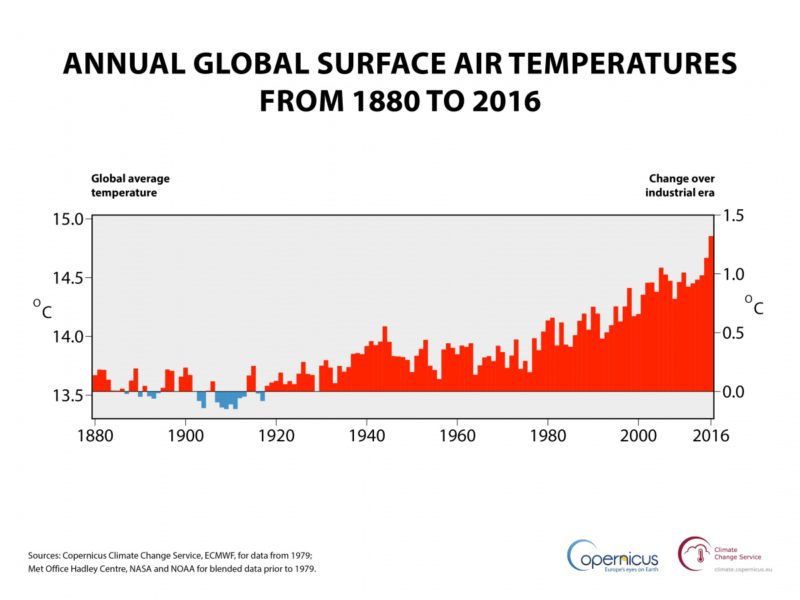
The first global analysis of the whole of 2016 has confirmed last year as the warmest on record and saw the planet near a 1.5°C warming, according to the Copernicus Climate Change Service (C3S).
Annual global air temperature at a height of two metres (left axis) and estimated change from the beginning of the industrial era (right axis). Sources: Copernicus Climate Change Service, ECMWF, for data from 1979; Met Office Hadley Centre, NASA and NOAA for blended data prior to 1979. (Credit: ECMWF, Copernicus Climate Change Service)
The latest figures from C3S, part of the EU’s Copernicus earth observation programme, show that 2016’s global temperature exceeded 14.8°C, and was around 1.3°C higher than typical for the middle years of the 18th century. 2016 was close to 0.2°C warmer than 2015, which was previously the warmest year on record.
Countries agreed in Paris in 2015 to holding the increase in the global average temperature to well below 2 °C above pre-industrial levels and to pursue efforts to limit the temperature increase to 1.5 °C above pre-industrial levels, recognising that this would significantly reduce the risks and impacts of climate change.
A more dangerous climate
Global warming, climate change increases the likelihood of extreme weather events such as heatwaves, droughts and floods. Future warming could cause billions of euros of damage each year and affect the availability of fresh water and crop yields in the most vulnerable countries.
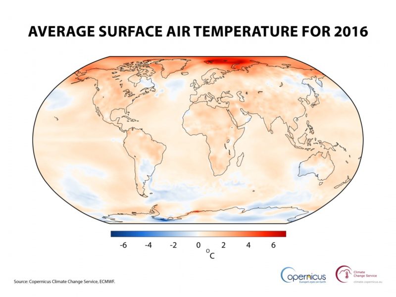
Air temperature at a height of two metres for 2016, shown relative to its 1981-2010 average. Source: Copernicus Climate Change Service, ECMWF. (Credit: ECMWF, Copernicus Climate Change Service)
Director of ECMWF’s Copernicus Services, Juan Garcés de Marcilla, said: “We are already seeing around the globe the impacts of a changing climate. Land and sea temperatures are rising along with sea-levels, while the world’s sea-ice extent, glacier volume and snow cover are decreasing; rainfall patterns are changing and climate-related extremes such as heatwaves, floods and droughts are increasing in frequency and intensity for many regions. The future impact of climate change will depend on the effort we make now, in part achieved by better sharing of climate knowledge and information.
“To help decision-makers develop effective adaptation and mitigation solutions we make the data from Copernicus Climate Change Service (C3S) and the Copernicus Atmosphere Monitoring Service (CAMS) freely and openly available. By mainstreaming the information that the Copernicus Services hold into climate policy and strategy, governments, the private sector and society can identify and unite around opportunities to tackle further climate change and reduce vulnerability where its effects are unavoidable.”
C3S found that global temperatures in February 2016 already touched the 1.5°C limit, though under the influence of a strong El Niño, an intermittent event involving a period of warming. Global temperatures still remained well above average in the second half of 2016, associated partly with exceptionally low sea-ice cover in both the Arctic and Antarctic.
C3S found that most regions around the world experienced above-average temperatures during 2016. The largest differences in regional average temperatures were found in the Arctic but conditions were also extreme over southern Africa early in the year, over southern and south-eastern Asia prior to the summer monsoon, over the Middle East later in summer, and over parts of North America in summer and autumn.
In addition to record temperatures, ECMWF’s Copernicus Services monitored other extremes occurring in 2016, including significant global wildfires and the growth of CO2 in the atmosphere. Destructive fires were observed around Fort McMurray, Canada in May and then extensive wildfires across Siberia, associated with the year’s high surface temperatures, during June and July.
For the first year CO2 levels did not return below 400 ppm as summer turned to autumn in the Northern Hemisphere. In previous years, take-up of CO2 by vegetation during the summer growing season has typically seen September mark the lowest point for CO2 levels.
Copernicus temperature data are based on millions of diverse daily measurements analysed by the European Centre for Medium-Range Weather Forecasts (ECMWF) using methods developed for weather forecasting.
Annual global temperature variations derived from Copernicus data and from other widely used sets of data typically agree to better than 0.1°C for recent years. The spread in values is likely to be larger than 0.1°C for 2016 due to differences in the extent to which datasets represent the warm conditions associated with exceptionally low sea-ice cover.
The estimate used here is that the climatological average temperature around the start of the Industrial Revolution is estimated to have been 0.7°C lower than that for 1981-2010.
Copernicus is the European Commission’s flagship earth observation programme that delivers freely accessible operational data and information services. It provides users with reliable and up-to-date information through a set of services related to environmental and security issues.
C3S is run by ECMWF on behalf of the European Commission. ECMWF is an independent intergovernmental organisation, producing and disseminating numerical weather predictions to its 34 member and co-operating states.
As three United Nations bodies come together to work as one to address the root environmental causes of ill health, Dr Margaret Chan (Director-General of the World Health Organisation – WHO), Erik Solheim (Executive Director of the United Nations Environment Programme – UNEP) and Petteri Taalas (Secretary-General of the World Meteorological Organisation – WMO) stress the need to clean up the global environment, which they describe as a “deadly zone”
World Health Organisation (WHO) Director-General, Dr. Margaret Chan. Photo credit: Alain Grosclaude/AFP/Getty Images)
There are many compelling reasons why we need to clean up the global environment. One of the most pressing is that a polluted environment is a deadly one. Every year, almost 12.6 million people die from diseases associated with environmental hazards, such as air, water or soil pollution, and climate change. That is one in four deaths worldwide.
We now know that the single greatest environmental risk to human health is through our most basic need – the air that we breathe. For years, governments have struggled to improve access to energy so they can promote economic development. But the largely unsustainable energy path that the world has followed has come at an unacceptable cost. Air pollution, overwhelmingly resulting from energy production and use, causes heart and lung diseases and cancer, resulting in approximately 6.5 million deaths each year.
The energy sources that cause the release of deadly air pollutants, such as black carbon, also release greenhouse gases, including methane and carbon dioxide. Together, these drive climate change, which threatens to undermine all of the environmental conditions on which human lives depend – food, water, and shelter.
Urbanisation and environmental health
Erik Solheim, Executive Director of the United Nations Environment Programme (UNEP) Photo credit: OECD/Michael Dean
By 2050, 66% of the world’s population will live in urban areas, which are often characterised by pollution as well as heavy traffic, poor housing, limited access to water and sanitation services and other health risks.
Environmental risks to health, like many of the challenges facing our world, are too complex and interconnected to be dealt with by simplistic, short-term solutions or by individual actors. That’s why the 2030 agenda for sustainable development, adopted by all countries, is so important. This, the world’s first ever global development plan, offers a unique opportunity for coherent, long-term action by all of society for all of society.
Many governments are now bringing several ministries and departments together, for example linking up environment, climate and health sectors, to take joint action. We saw this recently at the Conference of the Parties to the United Nations Framework Convention on Climate Change when ministers of health and environment answered a call by the Government of Morocco to sign the Marrakech Ministerial Declaration on Health, Environment and Climate Change. The declaration recognises that there is currently no global mechanism to bring the environment and health sectors together to work on saving lives and protecting the planet, and calls on the relevant United Nations (UN) agencies to put a mechanism in place.
The challenge now is to follow up this declaration with actions.
Petteri Taalas, Secretary-General of the World Meteorological Organisation (WMO)
Simple interventions, such as reducing vehicle emissions and investments in rapid transit systems, will save lives. Benin, Côte d’Ivoire, Ghana, Nigeria and Togo have committed to introduce low sulphur fuels by July 2017. Athens, Madrid, Mexico City and Paris plan to ban diesel vehicles by 2025. Implementing proven interventions to address short-lived climate pollutants could save over 2.4 million lives a year, and reduce global warming by approximately 0.5 C, by 2050. In many cases the benefits will more than cover the cost of intervention.
Failure to take into account the health impacts of air pollution and other environmental damages is estimated to amount to a $5.3 trillion subsidy to polluting energy sources. Failure to protect populations from environmental risks is not just a human cost, but places an additional strain on health services. Health service-related cost is among the largest financial burdens for governments and individuals.
Just as it is in both the individual and the collective interest of countries and ministries to work together to address complex problems, it is essential for all UN agencies to work more closely together to support them.
The Marrakech Declaration
The United Nations Environment Programme (UNEP), the World Meteorological Organisation (WMO) and the World Health Organisation (WHO) are working together to support countries to follow through on the aims of the Marrakech Declaration. We are committed to joining our technical and financial resources behind a single environment and health plan. Air pollution will be our first priority due to the huge health impacts that it causes, as well as its close links with other risks, such as climate change and chemical contamination.
Each of us will bring our wealth of expertise in climate, health or environment. WMO, through national meteorological agencies and their network of ground and remote-sensing stations, provides the essential data on climate, and air quality conditions, and facilitates the delivery of related weather and climate services. UNEP works with Member States’ Ministries of Environment and other key policy-makers to help prevent and reverse environmental degradation, thereby supporting individuals and communities. WHO, with national Ministries of Health, monitors and assesses health exposures and health impacts, and provides guidance on how to reduce them.
By June 2017 our agencies will have developed a joint plan, seeking wider engagement from other agencies and from the scientific, environment and health communities at large. In the words of the African proverb: “If you want to go fast, go alone; if you want to go far, go together.”
China will plow 2.5 trillion yuan ($361 billion) into renewable power generation by 2020, the country’s energy agency said on Thursday, January 5 2017, as the world’s largest energy market continues to shift away from dirty coal power towards cleaner fuels.
A security guard stands in front of windmills used to generate energy in Shanghai. Photo credit: Reuters/Aly Song
The investment will create over 13 million jobs in the sector, the National Energy Administration (NEA) said in a blueprint document that lays out its plan to develop the nation’s energy sector during the five-year 2016 to 2020 period.
The NEA said installed renewable power capacity including wind, hydro, solar and nuclear power will contribute to about half of new electricity generation by 2020.
The agency did not disclose more details on where the funds, which equate to about $72 billion each year, would be spent.
Still, the investment reflects Beijing’s continued focus on curbing the use of fossil fuels, which have fostered the country’s economic growth over the past decade, as it ramps up its war on pollution.
Last month, the National Development and Reform Commission (NDRC), the country’s economic planner, said in its own five-year plan, that solar power will receive 1 trillion yuan of spending, as the country seeks to boost capacity by five times. That’s equivalent to about 1,000 major solar power plants, according to experts’ estimates.
The spending comes as the cost of building large-scale solar plants has dropped by as much as 40 percent since 2010. China became the world’s top solar generator last year.
“The government may exceed these targets because there are more investment opportunities in the sector as costs go down,” said Steven Han, renewable analyst with securities firm Shenyin Wanguo.
Some 700 billion yuan will go towards wind farms, 500 billion to hydro power with tidal and geothermal getting the rest, the NDRC said.
The NEA’s job creation forecast differs from the NDRC’s in December that said it expected an additional 3 million jobs, bringing the total in the sector to 13 million by 2020.
Concerns about the social and economic costs of China’s air pollution have increased as the northern parts of the country, including the capital Beijing, have battled a weeks-long bout of hazardous smog.
Illustrating the enormity of the challenge, the NEA repeated on Thursday that renewables would still only account for just 15 percent of overall energy consumption by 2020, equivalent to 580 million tonnes of coal.
More than half of the nation’s installed power capacity will still be fueled by coal over the same period.
Africa’s Small Island Developing States (SIDS) came under scrutiny at the recently held UN climate change summit in Marrakech, Morocco, where scientists expressed concern over the grim prospects facing the hapless nations.
Waves slam Ilha de Sal in Cape Verde as area is hit by Hurricane Fred in 2015. SIDS are highly vulnerable to hydro-meteorological hazards and climate change
The countries are: Mauritius, Seychelles, Comoros, Cabo Verde (Cape Verde), Sao Tome & Principe, and Guinea Bissau. SIDS are are low-lying coastal countries that tend to share similar sustainable development challenges, including small but growing populations, limited resources, remoteness, susceptibility to natural disasters, vulnerability to external shocks, excessive dependence on international trade, and fragile environments.
At a side-event on “Innovative solutions to climate change challenges for the SIDS” organised by the SYAH Cabo Verde, the African Climate Policy Centre of the United Nations Economic Commission for Africa (UNECA) and the World Meteorological Organisation (WMO), participants stressed the need to build resilience in the SIDS countries, in the light of the fact that they are highly vulnerable to hydro-meteorological hazards and climate change.
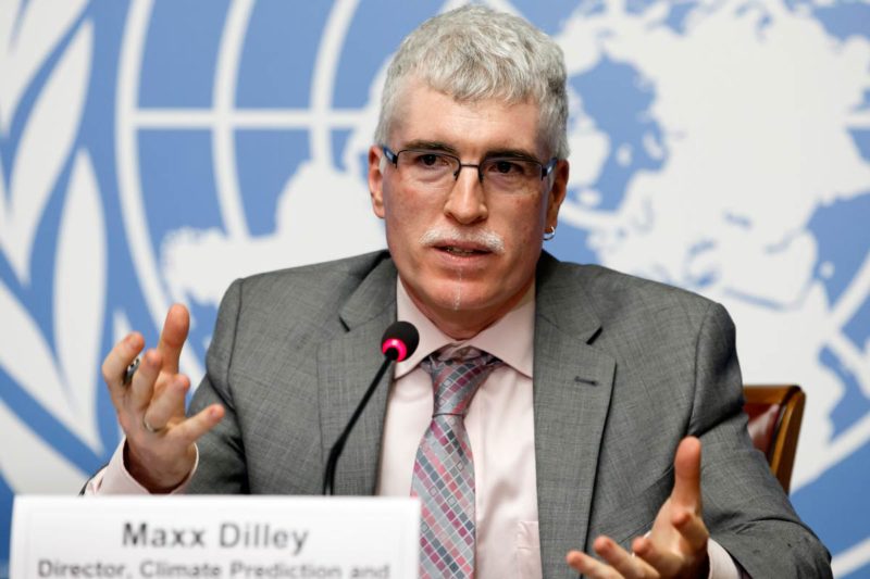
“There is need to develop capacity to undertake effective long-term planning and implement decision making mechanisms to assist SIDS to manage the multi-sectoral risks that they face and enable them to transition to blue and green economies,” says Dr Maxx Dilley, Director of Climate Prediction and Adaptation at the WMO.
Dr Maxx Dilley, Director of Climate Prediction and Adaptation at the World Meteorological Organisation
According to him, climate related extremes are likely to increase in SIDS with the acceleration of the hydrologic cycle due to global warming, adding that sea-level rise is an existential threat for some countries.
He points out that over 335 major natural disasters have occurred across all SIDS since 2000, resulting in an estimated $22.7 billion in direct damages. “For example, Hurricane Fred in Cabo Verde (2015) led to nine deaths and $1.1m in economic losses,” he adds.
Consequently, Dilley stresses, besides strengthening collaboration with existing policy mechanisms in the continent to prioritise the SIDS issues, the WMO is providing weather and climate services. “This is with particular attention to marine services, renewable energy, and tracking loss and damage, should be included in National Adaptation Plans and Nationally Determined Contributions of the United Nations Framework Convention on Climate Change (UNFCCC).”
His words: “The WMO is developing National Strategic Plans for NMHSs – endorsed at the national level, which would include: Weather and climate services, Systematic marine and coastal observations, Increased capacity development, Improved marine research and South-South (including SIDS-SIDS) cooperation and partnerships.”
Dr Joseph Intsiful, Senior Climate Science Expert, African Climate Policy Centre, UNECA
Similarly, Dr Joseph Intsiful, Senior Climate Science Expert, African Climate Policy Centre, UNECA, in a presentation titled “Supporting African SIDS to Manage Climate Risks,” points out that while the SAMOA Pathway articulates the unique challenges of SIDS in addressing climate variability and change and Disaster Risk and calls for urgent action to manage climate risks, the Paris Agreement requires urgent action to manage/reduce the existential threat facing SIDS.
“This is in the light of the fact that Africa’s aquatic and marine resources remain largely unexploited and being recognised for its potential contribution to inclusive and sustainable development,” he says, adding that the forum presents an opportunity to link the Blue Economy sectors, with high productivity potential, to accelerating structural transformation, primarily in Coastal and Island States in the region.
He lists solutions in this regard to include: Making climate information widely available African-wide with specific focus on African SIDS, Numerical Weather Prediction & Early Warning System, Forecasting Hurricane Fred over Cabo Verde, Workshops on Use of ACPC-ClimDev Numerical Weather Prediction and Early Warning System, Setting up of Numerical Weather Prediction System and Climate Services Information Systems Africa-wide, and Wireless Connectivity in Indian Ocean SIDS.
Intsiful discloses: “This is the first time such an e-infrastructure is being widely deployed continentally and addressing the unique needs of SIDS. It is state-of-the-art and cost-effective – based on Opensource tools and data. Climate Services Information System was installed/deployed by and maintained by ClimDev experts. Also, data analysis and visualisation system were installed/deployed by ClimDev experts.”
The event was also graced by dignitaries such as Antonio Palazuelos Prieto (Executive Director of SYAH Cabo Verde), Dr Justus Joseph Kabyemera (Coordinator, ClimDev Africa Special Fund in the Africa Development Bank), and Dr Pradeep Mongo (United Dations Industrial Development Organisation).
A new study has highlighted how achieving the Paris Agreement – global warming of no more than 1.5º Celsius over pre-industrial levels – would affect global fisheries.
It is believed that fishing catches in the tropical Pacific Ocean would shrink by 12 percent if the 1.5 degree rise in temperature is met
It is currently unclear how the world will achieve the climate target, but the fisheries support the diets, livelihoods, and cultures of billions of people.
According to simulations from computer models, the fishing industry would strongly benefit from meeting the Paris Agreement target. The maximum catch potential of fish would increase by three percent for every degree Celsius decrease in surface temperature, report the researchers in a recent edition of Science.
Fishing catches in the tropical Pacific Ocean would shrink by 12 percent if the 1.5 degree rise in temperature is met, while a 3.5 degree increase would lead to a reduction of 47 percent. The benefits for vulnerable tropical countries are therefore a strong support for the 1.5° C goal.
“People living in these regions rely heavily on fish as their primary protein source from animals,” says Thomas Frölicher, coauthor of the study and a senior scientist at the ETH Zurich Institute of Biogeochemistry and Pollutant Dynamics.
By contrast, Arctic fishing boats could see their catch increase by a fifth for every degree Celsius rise in surface temperature. The warming will have a positive effect on fisheries in the Arctic region, because it reduces the amount of sea ice and allows more light and heat to penetrate the ocean. This promotes the growth of phytoplankton, which in turn boosts fish stocks.
In addition, fish stocks in the Arctic region will increase due to the invasion of species from warmer low latitude regions. If the 1.5° C target agreed in Paris could be met, Arctic fishermen would see their catch increase by about 30 percent. A rise in surface temperature of 3.5° C would boost their catch by 55 percent. In extreme cases, the local catch could even quadruple.
Fish stocks in the high northern latitudes will not necessarily always benefit from the ocean’s increased warming and productivity, however. A tipping point would eventually arrive, after which the increase in temperature has negative consequences for Arctic fisheries.
For example, fish stocks in the North Sea will start to decrease again as soon as the average temperature rise exceeds about 3.5 degrees. This is because high water temperatures result in more stable stratification of the ocean, which in turn inhibits the growth of phytoplankton.
“The correlation between the average global temperature and the cumulative manmade carbon-dioxide emissions into the atmosphere is linear, just like the connection between global fishing yields and temperature,” explains Frölicher. This makes it possible to directly calculate the impact of one tonne of CO2 emissions on the global fishing catch.
At present, the resolution of the climate models is to some extent not high enough to make robust predictions for individual coastal regions. Frölicher and his colleagues are therefore working on a follow-up study that will use climate models with much higher resolution.
Frölicher is part of a group of fish experts called the Nippon Foundation-Nereus Program, which lead author of the study, Professor William Cheung at the University of British Columbia, heads. The Canadian researchers have developed a computer program that lets them model the population of 900 different species of fish. It includes environmental conditions for the fish, such as water temperature, and the levels of nutrients and oxygen in the water. The team has combined these potential populations with existing climate simulations to determine the living conditions of fish under different climate scenarios.
Depending on the future climate change scenario, tropical fish currently living in waters between 27 and 29 degrees Celsius will be faced with water that is one to 2 degrees higher. However, many species will be unable to adapt to these conditions, also because warm water contains less oxygen. As a result, the fishes have to search for a new habitat.
“Once the temperature reaches a certain threshold, these fish will be forced to migrate to cooler waters in order to survive,” warns Frölicher.