From its birth, the storm was destined to become a monster.
It formed from air that was hot, moist and thick with clouds. It incubated in the sultry Gulf of Mexico, drawing power from water that was unusually warm.
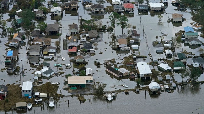
By the time Hurricane Ida made landfall in Port Fourchon, La., on Sunday, August 29, 2021, it was the poster child for a climate change-driven disaster. The fast-growing, ferocious storm brought 150-mile-per-hour wind, torrential rain and seven feet of storm surge to the most vulnerable part of the U.S. coast. It rivals the most powerful storm ever to strike the state.Though Ida was downgraded to a tropical depression Monday, it still poses a major threat as it makes its way across the southeast. Heavy rains could trigger flash flooding from Mississippi to Appalachia, including in areas where soils have already been saturated by an unusually wet summer.
“This is exactly the kind of thing we’re going to have to get used to as the planet warms,” said Kerry Emanuel, an atmospheric scientist at the Massachusetts Institute of Technology who studies the physics of hurricanes and their connection to theclimate.
According to the United Nations’ latest climate report, warming from fossil fuel use and other human activities is likely behind an increase in the number of high intensity hurricanes in the past 40 years.
Hurricane Ida is the latest storm to batter the United States this summer. Tropical Storm Henri weakened as it inundated coastal communities in New England earlier this month, but it still knocked out power to more than 120,000 homes in three states and dumped a record 1.89 inches of rain on New York City in just one hour.
And hurricane season is far from over, as five other tropical systems are now sweeping over the Atlantic Ocean.
But for now, all eyes are on Ida.
Scientists had been bracing for the worst since the moment forecasters identified a tropical depression forming last week. The Gulf of Mexico in August is always a hotbed of hurricane formation. “This time of year, it’s like bathtub water,” said Brian Tang, an atmospheric scientist at the University at Albany in New York.
Lately, conditions in the ocean have been exceptionally bad. According to the National Oceanic and Atmospheric Administration, parts of the Gulf are three to five degrees Fahrenheit higher than the average for the end of the 20th century. Research shows that human greenhouse gas emissions have caused the ocean to warm faster in recent years than at any point since the end of the last ice age.
All this warm water is to hurricanes what gasoline is to a car engine, Tang said. A powerful storm takes energy from the ocean and converts it into roiling clouds and roaring winds.
As Ida developed, it travelled over the hottest parts of the gulf, sucking up energy to fuel its rapid growth. With no shifting upper atmosphere winds to disrupt it, the ring of thunderstorms around the hurricane’s centre – called the eyewall – started to churn faster and faster.
Even worse, the sea surface temperature rose as the hurricane got closer to the coast.
“That’s really like stepping on the accelerator,” Tang said. “Flooring it, basically.”
Barely 24 hours after it was identified as an unnamed tropical depression in the Caribbean on Thursday, its wind speeds reached 75 miles per hour – enough for the storm to be upgraded to a hurricane. By Saturday night, winds were hitting 105 miles per hour, making Ida a Category 2 storm.
Kimberly Wood, an atmospheric scientist at Mississippi State University, went to bed with a sinking feeling in her gut.
She woke Sunday to reports from the National Hurricane Centre that peak winds were at 150 miles per hour. She thought of all the people who would not have time to evacuate in response to the sudden escalation.
She looked again at satellite images showing what scientists call a “well-organized” storm.
Wood wishes that the scientific terminology didn’t sound so much like a compliment. “It sounds like we’re cheering it on, but we’re not,” she said. “I feel sick to my stomach.”
Emanuel of MIT calls such rapid intensification a “canary in the mine” for climate change. Warmer conditions raise the “potential intensity” for storms — in other words, how bad they can get if nothing disrupts them. Climate change has also widened the disparity between the amount of heat in the ocean and the amount of moisture the atmosphere can hold, which accelerates the process of evaporation and energy transfer.
“Things happen faster,” he said. “It’s getting to a larger velocity, and it’s taking less time to get there.”
In a 2017 paper published in the Bulletin of the American Meteorological Society, Emanuel found that once-in-a-century intensification events – in which wind speeds accelerate about 70 miles per hour in just 24 hours – could happen every five to 10 years by 2100. Human-caused warming could lead to never-before-seen escalation of hurricanes, causing unheard-of surge in wind speeds of 100 miles per hour or more.
By Sarah Kaplan, The Washington Post